|
|
Willamette
National Forest
|
|
|
|
Explore the Detroit Ranger District! Detroit Ranger District is located in the northern part of the Willamette National Forest, bordering Mt. Hood National Forest and the Warm Springs Indian Reservation. This area is accessible from the west on Highway 22 from Salem, from the east on Highway 22 via Highway 20/126 from the Santiam Pass area, or from the north on Forest Road 46 from the Mt. Hood National Forest. Camping: Here you will find popular campgrounds in the Detroit Lake Area, as well as Breitenbush Campground and Shady Cove Campground that serve as the base for adventures such as hiking, horseback riding, OHV riding, swimming, and more.. Hiking Incredible vistas await while backpacking in the popular Mt. Jefferson - Jefferson Park Trail Area and the Opal Creek Wilderness and Scenic Trail Area. Many day hiking opportunities can be found throughout the district such as the Detroit Reservoir Trail Area and Coffin Mountain Trail Area. Other Recreation Many areas offer great boating or swimming such as the Elk Lake Campground, and Three Pools Day Use Area.
Detroit Lake Area: The 3,500 acre lake is located in the Cascade Mountains below Mt. Jefferson on the Willamette National Forest. The U.S.Army Corps of Engineers built the lake and dam in 1951-53. The lake stores water of the North Santiam River, controlling runoff and providing flood control, irrigation, downstream navigation improvement, recreation and power generation, while preserving the quality of the North Santiam Canyon environment.
Cove Creek Campground: With 64 sites, Cove Creek Campground is the largest National Forest Campground on Detroit Lake. The campground offers single and double-family campsites, as well as an ccessible group site for up to 70 people. Accessible flush toilets, drinking water and coin-operated showers are available at Cove Creek. Cove Creek Group Campground comes with a sheltered eating area. The
Stahlman Point Trail #3449 is located 1/4 mile from entrance road and offers some great views of Detroit Lake and Mount Jefferson.
Hoover Campground: Whether you are camping, renting the adjacent Hoover Group Site, planning on boating in Detroit Lake, or just staying for the day to fish off the accessible fishing pier, Hoover Campground is a great family location with 37 sites. An interpretive trail and a viewing and fishing platform are part of the campground. Each site has a campfire ring and picnic table. Flush toilets are available at the campground and the group campground has a vault toilet. Access roads are made from compacted rock and dirt. Firewood can be purchased on-site. Located near Highway 22, Hoover Campground gives you easy access to these activities and also allows for quick trips into the town of Detroit or short drives to nearby trailheads.
|
|
|
|
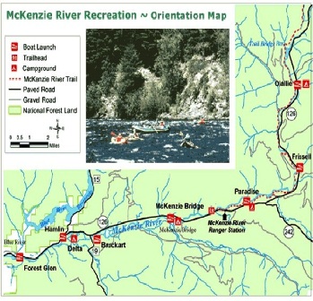
The McKenzie River Ranger District is in the middle part of the Willamette National Forest, bordering the Deschutes National Forest. Accessible from the west via Highway 126 from Eugene, OR, or from the east on Highway 20 from Sisters. The McKenzie River Ranger District is a collection of stunning lakes and waterfalls, epic mountain biking and rafting, and opportunities to explore history. Hiking: Get your water fix at the Upper McKenzie Trail Area hiking the Water Falls Loop Trail #3503 where you can see the popular Sahalie and Koosah Falls. View the headwaters of the McKenzie River at the stunning Clear Lake Loop Trail #4341. Other Recreation: The Olallie Trail Area and Upper McKenzie Trail Area offer some of the best mountain biking on the forest. Road cyclists will love the challenge of the McKenzie Pass-Santiam Pass National Scenic Byway and the views are spectacular from your vehicle as well! Don't miss the Dee Wright Observatory, along the scenic McKenzie Highway (Hwy 242), for panoramic views of Cascade peaks such as Mount Washington and the Three Sisters. For Highway 242 opening and closing dates, check Oregon Department of Transportation website. History buffs will enjoy a stop at Fish Lake Interpretive Day Use, or try spending a night at an historic guard station (reservations required) such as Box Canyon Guard Station or Indian Ridge Lookout. Take a guided trip down the river with one of our McKenzie River Permitted Outfitters & Guides.
Big Lake Campground /
Big Lake West Campground On the western shore of Big Lake at the top of Santiam Pass, surrounded by alpine fir, hemlock and lodgepole pine, campers enjoy views of the lake with the beautiful Mt. Washington as a backdrop. Big Lake Campground offers about 30 spacious campsites for tent or RV camping. Drinking water, vault toilets and a boat ramp are provided. This campground is a hub of activity during the summer months. Big Lake is very popular for both motorized and non-motorized boating. The campground is located adjacent to the Santiam Pass Motorized Recreation Area (area is unavailable) and is a popular campground for OHV enthusiasts. Nearby
Patjens Lakes Trail offers easy access to the
Mt. Washington Wilderness.
Big Lake Area Big Lake is 225 acres in size and is situated on the historic Santiam Wagon Road. It was the first resting place for early travelers heading west. A youth camp operates under special use permit on the east side of the lake. Volcanic peaks and cinder cones visible from the lake include Mt. Washington, Sand Mountain, Hoodoo Butte, Hayrick Butte and Three Fingered Jack. Big Lake is popular for motor boating and water skiing, as well as camping, picnicking, fishing and swimming. Access to wilderness trailheads is located nearby. The nearby Santiam Pass Dispersed Motorized Recreation Area is open to Off-Highway Vehicles. A boat launch is located in the Big Lake Day Use Area (fee required). Two campgrounds are situated on the lake.
Blue River Reservoir Area The reservoir is primarily used as storage for floodwaters in winter, but is filled for the summer recreation season. The reservoir is 6.4 miles long, 1,420 acres when full; the dam is 1,265 feet long and 270 feet high. Water levels and boat ramp accessibility information is available from the Oregon State Marine Board website. Look for Blue River Reservoir in the section titled "Willamette Basin Reservoirs." Watch for obstructions near the shoreline such as submerged stumps, logs, and rocks. Small craft should stay out of open waters when it's windy since dangerous waves can build up suddenly.
Clear Lake Area Clear Lake, the "lake born of fire," is the headwaters of the McKenzie River and was formed 3,000 years ago when lava from Sand Mountain reached the river and backed up water to form the lake. The original forest lining the river banks was submerged. Remnants of some of these submerged trees still stand under 120 feet of water and are visible from the trail and by boat. The nearly freezing temperature of the lake makes it unsuitable for swimming. A picnic shelter, built by the Civilian Conservation Corp, is situated at the
day use area near the resort. Osprey and bald eagles, and native cutthroat trout call the lake home. Non-native rainbow and brook trout are also found in the lake.
Cougar Crossing Campground Located on the confluence of the South Fork of the McKenzie River and the south end of Cougar Reservoir, Cougar Crossing is open year round and offers 11 sites that can accommodate either RV or tent camping. Vault toilets are provided. There is firewood for sale. The interior roads and spurs are gravel. There is no drinking water. The
Three Sisters Wilderness lies directly east of the site.
Cougar Reservoir: The reservoir is maintained at a high level for scenic and recreational enjoyment from May through August.
Slide Creek Campground The mixed conifers at Slide Creek Campground provide a beautiful wooded setting for this unique camping destination along the east bank of the Cougar Reservoir just 50 miles from Eugene, Oregon. Both campground and the
day use area guests have access to drinking water, vault toilets, a boat ramp, ample parking and a swimming beach. A separate parking lot is available for boat trailers. The 8 campsites can accommodate tents, trailers or RVs and come equipped with campfire rings and picnic tables. It is known for handy access to boating and many water activities. It is also near Terwilliger Hot Springs, an area with soaking pools fed by the Rider Creek waterfall.
Delta Campground Known for its access to rafting and drift boat fishing on the McKenzie River, This scenic 38 site campground is located in a grove of old growth trees. Some of these ancient sentinels, predominantly Douglas fir and western red cedar, are centuries old and make for an enchanting setting. Access to the river, Cougar Reservoir and Terwilliger Hot Springs make this campground a great spot for camping and exploring the area. Several hiking trails are in the surrounding wilderness, guarded by large Douglas fir and western red cedar trees. Visitors can also enjoy a short botanical walk on the Delta Old Growth Nature Trail. A Day Use area and amphitheater are also available at the campground.
Ice Cap Creek Campground This scenic campground is located in a stand of Douglas fir, cedar and hemlock on a bluff above the McKenzie River and Carmen Reservoir. Ice Cap Creek runs along the eastern edge of the campground. Ice Cap offers 22 campsites with 9 that are walk-in tent sites. The other 13 can accommodate either tents or RVs. Each site has a fire ring and picnic table. There are vault toilets, firewood for sale, and a host onsite. There is no drinking water. The location provides easy access to the
McKenzie River Trail #3507 and to
Koosah and Sahalie Falls. The McKenzie Wild & Scenic River is well known for boating and fishing as are Carmen Reservoir, Fish L ake and Clear Lake.
McKenzie Bridge Campground This 13-site campground rests in the shade of a towering grove of Douglas-fir and western red cedar along the banks of the McKenzie River and provides an ideal atmosphere for relaxation, fishing, and bird watching. Enjoy the sights and sounds of the McKenzie River as you watch boaters and rafters float by. Campsites are nicely spaced and all have riverfront access. Vault toilets and drinking water are provided. Parking areas are gravel surfaced. At the campground, the river provides catch-and-release fishing for trout and steelhead. Kayaking and canoeing are also popular activities. A boat ramp is located on-site. The McKenzie River National Recreation Trail begins nearby, offering fun-filled hiking and biking opportunities. The 26-mile trail boasts wonderful scenery along the river and is an easy hike for all ages.
Olallie Campground Nestled on the banks of the McKenzie River and Olallie Creek, Olallie Campground provides 16 sites with a superb setting for a getaway into nature. The lower loop offers mesmerizing views of both the river and the creek while the upper loop is set further in the trees with many sites facing the creek. No electric hookups are available at the campground. Picnic tables, vault toilets and drinking water are among the amenities available. A camp host is on-site, and firewood is available for purchase. Fishing, rafting and swimming are three top activities in the river. Picnicking is also a lot of fun at the campground. Nearby is the McKenzie Pass Trail Area with incredible hikes around lakes, overlooking cliffs, and trailing along craters and valleys. Know Before You Go: This campground is in central Oregon near McKenzie Bridge on the Willamette National Forest. There is another "Olallie" near Mt. Hood, Oregon.
Paradise Campground Paradise Campground is indeed a paradise for campers. Originally built by the Civilian Conservation Corps in the 1930s, it offers a rare opportunity to camp in the middle of a lush, old growth grove of Douglas fir and western red cedar while viewing the McKenzie River's famous white water. A number of the 33 face the river, while many others are tucked into the scenic forest. Flush toilets are dispersed throughout the campground and parking spurs are paved. Educational programs are provided at the amphitheater.
Smith Reservoir Area The reservoir spans 170 acres at capacity. There is one campground (only accessible by boat) located across the reservoir 1.8 miles north from the boat launch. Watch for obstructions near the shoreline such as submerged stumps, logs, and rocks.
Trail Bridge Reservoir Area The reservoir is maintained at a high level for scenic and recreational enjoyment from May through August. Reservoir spans 120 acres at capacity. Access to the
McKenzie River National Recreation Trail is close by. Watch for obstructions near the shoreline such as submerged stumps, logs, and rocks.
The Middle Fork Ranger District is the southern part of the forest, bordering the Deschutes and Umpqua National Forests. Accessible from the west on Highway 58 from Eugene, OR, or from the south via Highway 58. Waldo Lake is one of the gems of the forest, but don't forget to get out on some of the great mountain biking, hiking, and horse trails in this area.
Hiking: Backpacking and day hikes can be found all over the district including,
Fall Creek Trail Area, and
Hardesty Trail Area. For spectacular mountain scenery, try a hike in the
Willamette Pass Trail Area.
Other Recreation: The renowned
Middle Fork Willamette Trail,
North Waldo Trail Area and
South Waldo Trail Area are just a few of the more popular mountain biking areas. One of the gems of the Willamette National Forest is the
Waldo Lake Area provides many recreational opportunities including horse camping, non-motorized boating, swimming, hiking and biking. For those who prefer to travel by horse, the spectacular
Diamond Peak Trail Area offers multiple trails For those that enjoy travel of the motorized type, OHV enthusiasts can enjoy the
Huckleberry Flats OHV Trail.
Bedrock Campground Located in a dynamic landscape setting shaped by fire, Bedrock Campground is situated on a terrace above Fall Creek where the hillsides surrounding the camp offer an impressive fireweed bloom display during the summer months. There are 21 sites. Expect heavy use on summer weekends from visitors escaping high temperatures in nearby urban areas.
Black Canyon Campground With 72 campsites and located in a mature Douglas-fir and Western Red Cedar forest, this campground offers a cool respite from summer heat alongside the Middle Fork of the Willamette River. The campground offers some riverside sites with pleasant shade, fresh air with cool breezes. Each site contains a picnic table and campfire ring with grill. Accessible vault toilets and drinking water are provided. Located close to the city of Oakridge, the camp is directly off of Oregon State Highway 58. The boat ramp is open year round.
Blue Pool Campground This campground is conveniently located adjacent to Oregon State Highway 58 in an old growth forest alongside Salt Creek. There are 24 sites. Fishing and swimming are popular activities. A large picnic area along the creek offers picnic tables, a large grassy area for both passive and active recreation. One-half mile east of the campground on Highway 58 is the McCredie Day Use Site. The site was formally developed as a hot springs resort historically; currently the hot springs area is unimproved. Caution should be exercised when using the hot springs, water temperature is very high in the pools.
Gold Lake Area Gold Lake, situated in an open alpine forest, is a popular spot in both summer and winter. Although motors are not allowed on this small (100 acre, 25 feet deep) lake, canoes, rafts and rowboats provide excellent fishing access. A primitive log shelter built by the Civilian Conservation Corps (CCC) in the early 1940s provides a dry picnic area or overnight protection for cross country skiers in winter. Located very near the lake is Gold Lake Bog. This special area offers the visitor the opportunity to view deer, elk, and other smaller wildlife. In the late spring and summer this area abounds with wild flowers and huckleberries. This is a popular area to pick huckleberries in the late summer.
Gold Lake Campground This camp is situated near the Cascade crest with some sites adjacent to the picturesque Gold Lake. There are 21 sites. Visitors come for the alpine forest setting, quiet, autumn huckleberries, and wildlife viewing. The adjacent Gold Lake bog is ideal for viewing deer, elk, and beaver. Motors are prohibited on the small lake (100 acres in size and 25 feet deep), but non-motorized craft are permitted, such as canoes and float tubes. The lake is fly-fishing only; please consult the Oregon Department of Fish and Wildlife regulations for the most up-to-date information. A historic "Willamette Winged" log shelter exists in the day use area, and provides an overnight place for cross-country skiers during the winter, and a day-use facility during summer. The shelter was designed by William Parke, the Willamette National Forest's first Recreation Planner, and constructed with Civilian Conservation Corps labor during the early 1940s. Parke was a 1932 graduate of the Oregon State College of Forestry, and was training as a Landscape Architect at the University of Oregon when hired by the Forest Service.
Hills Creek Reservoir Area The 2,735-acre reservoir is located in the mountains of the Willamette National Forest, near the community of Oakridge. The Army Corps of Engineers built Hills Creek Reservoir in 1961. The dam was built to provide flood control, irrigation, power generation, water-based recreation and improved down stream navigation. The 44-mile shoreline of this reservoir is managed to provide habitat for a wide variety of wildlife and waterfowl.
Packard Creek Campground Packard Creek is a popular 37-site campground on the western side of Hills Creek Reservoir. The family-friendly destination offers a picturesque setting among tall trees, with views of the lake beyond. Most of the campground is accessible. Each campsite is equipped with a picnic table and a campfire ring. The group campground, which accommodates up to 80 people, has a large picnic shelter and open space for tents. Some sites have individual boat docks as well. The campground is busy on summer weekends, so plan your arrival accordingly. Popular recreational activities are swimming, boating, and fishing. Accessible parking is offered at the boat ramp/swimming area. Hikers, equestrians, and mountain cyclists can explore the Larison Creek Trail nearby. Be aware that there is an abundant supply of poison oak throughout the camp; use caution when walking off the paved roads.
Salmon Creek Campground This 15 site camp is located in a beautiful, lush, old growth forest right along Salmon Creek. The rocky gorge-like area creates two small beautiful waterfalls and several deep pools which reflect the clear blue-green waters. Wild thimbleberries and hazelnuts abound in the summer. This camp is a favorite recreation spot for local residents as well as some more distant travelers.
Waldo Lake Area Lying high on the western slopes of the Oregon Cascades, Waldo Lake is one of the largest natural lakes in Oregon (9.8 square miles with a maximum depth of 427 feet). Waldo is one of the purest lakes in the world. It has no permanent inlet to bring nutrients into the lake for plant growth. The lack of plant life contributes to its purity. You can see to depths of 120 feet on a calm day.
See more photos.
Islet Campground This 55 site campground is located at the north end of Waldo Lake and offers wonderful sandy beaches. Western winds consistently blow each afternoon, offering respite from early season mosquitoes, which are typically intense from June to mid-August so come prepared. The 1-mile Shoreline Trail between Islet and
North Waldo Campground provides a short and pleasant hike along the lakeshore.
North Waldo Campground North Waldo is the most popular of the Waldo Lake Campgrounds. There are 58 sites with fire rings and tables. There is a sanitation station near the campground. The drier environment supports fewer mosquitoes, but they are still plentiful in season so come prepared. The boat launch is somewhat deeper than the others on the lake, which is more accommodating for sailboats. Waldo Lake is one of the largest natural lakes in Oregon. It offers a uniquely peaceful setting on the water and along remote shorelines, surrounded by forests of Douglas fir and Western Hemlock. Recreation in the area is abundant with the lake an ideal location for water activities like sailing, canoeing and swimming. North Waldo is a popular starting point for many wilderness trails and lakes, most notably the Rigdon, Wahanna and Torrey Lakes. The 1-mile Shoreline Trail between North Waldo and Islet provides a short and pleasant hike along the lakeshore.
Shadow Bay Campground This 19-site campground is less busy than its neighboring campground,
North Waldo, resulting in a quieter atmosphere. It is situated in a lower and wetter landscape than North Waldo and Islet Campground and supports thicker and more diverse groundcover and generally more mosquitoes earlier in the season, so come prepared June to mid-August. Garbage containers and gray water disposal areas are available at the campground. Hikers, equestrians, and mountain bikers can traverse the Shore Line Trail to the historic South Waldo Shelter and then continue on the
Jim Weaver Loop #3590. Winding around to the west side of the lake, the public can catch glimpses of the lake through the high-elevation forest, or capture broad views of the High Cascades mountains from open viewpoints.
Sweet Home Ranger District is in the middle part of the Willamette National Forest. This area is accessible from the west via Highway 20 from Albany, OR, or from the east on Highway 20 from Sisters. Let the Sweet Home Ranger District give you a taste of the sweet life! You'll find mountain biking adventures, incredible wildflower hikes, swimming areas to keep cool on a hot summer day, and much more.
Guided Hikes Choose your own adventure or take a guided adventure on a
Sweet Home Heritage and Nature Tour.
Camping Keep cool on a warm summer day at one of the popular campground and swimming areas such as
Fernview Campground,
House Rock Campground, or
Trout Creek Campground.
Hiking If you like wildflowers take a hike in the
Old Cascade Crest Trail Area or the
Tombstone Pass Trail Area (especially
Iron Mountain Trail).
Other Recreation Grab your bike and get your legs and heart pumping on the
Santiam Wagon Road Trail Area and
Iron Mountain. Uncover the past at
Longbow Organization Camp.
Fernview Group Campground The 11 campsites at Fernview Group Site are perched high above a scenic portion of the South Santiam River which makes for a beautiful view. Fernview was originally a campground that has been converted to a group site. Individual campsites are available on a first-come, first-served basis when group campground is not reserved. Every site has a picnic table and fire pit/grill. There is a parking area adjacent to the bathroom that can also be used for RV parking; this area is suitable for 1 large or 2 small RV's, maximum 2 RV's. One hand pump provides water and there is a newer single CXT toilet on site. River access can be difficult from the campground, but is nearby via a short walk or drive. The
Rooster Rock Trailhead across Highway 20 is a portal to the
Menagerie Wilderness. The
Old Santiam Wagon Road runs through the back of the campground.
House Rock Campground House Rock Campground is perched on the confluence of Sheep Creek and the South Santiam River in an old growth forest grove at 1600-foot elevation with 17 campsites, including 5 tent-only sites. There is limited turn-around space, RVs or trailers over a total of 22 feet are not recommended. The campground road and parking spurs are composed of packed dirt and rock. The double-loop area comes with accessible vault toilets and drinking water from hand pumps. Picnic tables, campfire rings and grills are at each site. The campground host sells firewood. Campers can enjoy hiking the
House Rock Trail, which starts at the day-use area. Part of the trail shares paths with the historic
Santiam Wagon Road. Swimming is popular, especially because many sites have riverfront access to shallow swimming areas. Anglers can cast for native cutthroat trout.
Trout Creek Campground Trout Creek Campground is a fun, family campground situated along the South Santiam River, 20 miles east of the town of Sweet Home, Oregon. At 1200-foot elevation, many of the 24 sites are right on the river, tucked under the cool shade of Douglas-fir and Hemlock trees. The campground was built by the Civilian Conservation Corps (CCC) in the 1930s and includes a welcoming day use shelter with a fireplace and five pull-through RV parking loops and a mix of standard parking spurs. Drinking water is from a hand pump well. Parking spurs are gravel and roads are paved. Firewood is available for a fee. Plenty of river activities and hiking opportunities await. Wading and fishing are popular in the river and hikers enjoy easy access to the 2.8-mile
Trout Creek Trail and the short Walton Ranch Interpretive Trail. The
Menagerie Wilderness can be accessed from the Trout Creek Trail, so hikers and backpackers can explore the area's extensive system of trails. Visitors can enjoy a brisk swimming in the South Santiam River or if you are looking for a hike the Rooster Rock Trailhead is just across the road. This 3.3 (one-way) mile trail provides access to Rooster Rock, a stone pinnacle in the Menagerie Wilderness popular among rock climbers (rated 5.4). Additional nearby pinnacles are rated up to 5.9.
Yukwah Campground Yukwah Campground is a nice, family campground situated along the South Santiam River, 21 miles east of the town of Sweet Home, Oregon. Many of the 13 sites are right on the river, tucked under the cool shade of Douglas fir and hemlock trees. Two double sites are perfect for the bigger group or family. The campground was built by the Civilian Conservation Corps (CCC) in the 1930s and includes a welcoming day use shelter with a fireplace and five pull-through RV parking loops and a mix of standard parking spurs. This is a smaller campground with a variety of sites to accommodate different uses, with group sites, sites for trailers and sites for tents. Drinking water is from two hand pump wells. Parking spurs are gravel and roads are paved. Vault toilets and garbage cans are spread out in convenient locations in the campground. Firewood is available for a fee. Plenty of river activities and hiking opportunities await. Enjoy fishing and swimming in the beautiful South Santiam River or hiking the accessible
Yukwah Nature Trail that winds through the campground, and lingering at the picnic area. Hike or bike the Santiam Wagon Road (now a trail), a historic trail used to transport livestock east across the Cascade Mountains to central Oregon's grasslands. Iron Mountain, Gordon Meadows and Echo Basin are nearby hiking areas well known for their colorful wildflowers.